Why NASA’s ICESat-2 Mission Could Change Global Ocean Mapping Forever in 2025
Discover how NASA’s ICESat-2 satellite and groundbreaking ATL24 data product are pushing the boundaries of seafloor mapping in 2025.
- 2,000+ journal articles reference ICESat-2 satellite-derived bathymetry
- 6 years of global elevation data collected by ICESat-2
- ATL24: New global bathymetric dataset now available
- 1,000s of coastal regions mapped—faster than ever before
On September 15, 2018, NASA launched the ambitious ICESat-2 mission from Vandenberg Air Force Base. The goal: deliver highly detailed, globe-spanning measurements of Earth’s surface elevation. Six years later, the mission is entering a pivotal new phase, and its transformative toolkit is reshaping how we understand our oceans.
Recently, the spotlight shone on ICESat-2’s talents at a March 2025 Wilmington, NC, workshop. Scientists, industry leaders, and policy makers gathered to unveil the newest advances—and to chart the future of satellite-derived bathymetry (SDB), the innovative method of mapping the seafloor from space.
What Makes Satellite-Derived Bathymetry a Game Changer?
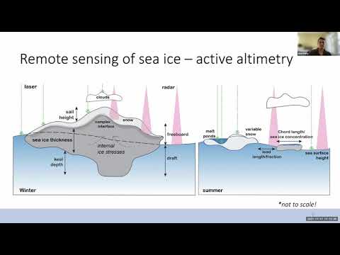
Satellite-derived bathymetry (SDB) uses state-of-the-art satellite lasers to measure ocean floor depths by analyzing how light penetrates and reflects back from water. This approach leapfrogs traditional methods—offering global coverage, quicker data, and reduced costs.
But SDB isn’t perfect. Murky waters, cloud cover, and satellite resolution still pose challenges. Even so, SDB is now a critical tool in fields ranging from coastal management to disaster response and marine habitat conservation.
Q: How Is ICESat-2 Supercharging Bathymetry?
ICESat-2 is armed with the Advanced Topographic Laser Altimetry System (ATLAS), firing rapid pulses of light to capture incredibly fine elevations—even beneath the sea’s surface. In 2025, the unveiling of the ATL24 dataset marked a milestone: it provides expansive, high-precision bathymetric data now accessible through the National Snow and Ice Data Center.
How Are These Datasets Used Around the Globe?
Government agencies, academics, and commercial players rely on these datasets to:
- Update nautical charts for safer navigation
- Predict flooding and storm surge impacts
- Spot changes in vulnerable coastlines and coral reefs
- Support marine biodiversity conservation
Executives from organizations like USGS, NOAA, and international mapping companies showcased real-world applications at the 2025 workshop, sharing case studies from Papua New Guinea to the Bahamas.
What’s New in Bathymetric Technology for 2025?
The workshop brought to light breakthrough software and methods, including:
- NOAA’s SatBathy desktop tool for fast SDB analysis
- Cloud-based mapping via EOMAP’s EoappTM SDB-Online
- The ATL13 dataset for lakes and shallow waters
- SlideRule Earth—a public web service enabling instant ICESat-2 data processing
In addition, the hybrid “Satellite Triangulated Sea Depth” (SaTSeaD) module combines photogrammetry and laser data for even more accurate coastal mapping.
Q: What Were the Key Takeaways from the NASA Workshop?
Collaboration is the new currency. The event fostered discussion between end-users, toolmakers, and scientists—paving the way for next-gen SDB applications still unimagined.
Accuracy was another hot topic: rigorous comparisons with ground truth data showed ongoing improvements, with each new data product refining how we see the ocean floor.
How Can You Access the Latest ICESat-2 Bathymetry Data?
The ATL24 global bathymetric data, as well as other SDB products, are now available through the National Snow and Ice Data Center and NASA’s open-access science web services. SlideRule Earth makes it easy to visualize and process these enormous datasets—no supercomputer required.
What’s Next for Satellite Seafloor Mapping?
The momentum signals that NASA and its global partners will roll out even more advanced mapping tools and datasets between now and 2030, further accelerating research and real-world impact for coastal resilience, ocean science, and climate adaptation.
Ready to explore the depths? Don’t miss this wave of data-driven ocean discovery—get involved, connect with the science, and help shape the future of global mapping!
Checklist: How to Dive Into Cutting-Edge Satellite Seafloor Mapping
- Access the new ATL24 bathymetric data at NSIDC
- Try public demo tools like SlideRule Earth to visualize ICESat-2 data
- Follow major developments at NASA, NSIDC, and NOAA
- Network at upcoming SDB and ocean mapping events
- Stay tuned for more open workshops and data releases through 2025