
Inside the Fallout: How Satellite Photos Reveal the True Consequences of U.S. Attacks on Iran’s Fordow, Natanz, and Isfahan Nuclear Complexes
- Current Landscape of Nuclear Facility Security and Surveillance
- Advancements in Satellite Imaging and Analytical Tools
- Key Players in Satellite Intelligence and Defense Monitoring
- Projected Developments in Nuclear Site Monitoring and Response
- Geopolitical Impact Across the Middle East and Beyond
- Evolving Strategies for Nuclear Security and International Oversight
- Barriers and Breakthroughs in Monitoring and Mitigating Nuclear Threats
- Sources & References
“The State of Artificial Intelligence: July 2025 Artificial Intelligence (AI) continues to transform every facet of society, from business and education to healthcare, entertainment, and geopolitics.” (source)
Current Landscape of Nuclear Facility Security and Surveillance
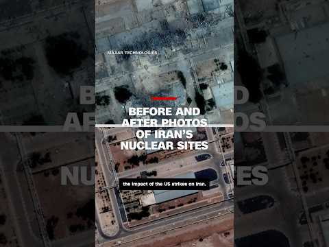
Recent satellite imagery has brought unprecedented clarity to the aftermath of U.S. airstrikes on Iran’s key nuclear facilities at Fordow, Natanz, and Isfahan. These high-resolution images, released by commercial providers such as Planet Labs and Maxar Technologies, reveal extensive structural damage, scorched earth, and disrupted security perimeters at these sites. The images have become a focal point for analysts, policymakers, and the international community, offering a rare, unfiltered look at the immediate consequences of military action on Iran’s nuclear infrastructure.
- Fordow: Satellite photos show collapsed roof sections and debris fields around the underground enrichment facility. The images suggest that precision-guided munitions penetrated hardened structures, raising questions about the resilience of Iran’s deeply buried centrifuge halls (Reuters).
- Natanz: The main enrichment complex at Natanz displays widespread scorch marks and craters, with visible damage to above-ground support buildings and perimeter fencing. The destruction of electrical substations and access roads is evident, likely disrupting operations and complicating immediate repairs (BBC).
- Isfahan: Imagery of the Isfahan site, which houses uranium conversion facilities, reveals fire damage and the apparent destruction of storage tanks. The proximity of blast marks to sensitive processing areas has heightened concerns about potential radiological hazards (Al Jazeera).
These revelations matter for several reasons. First, they provide independent verification of the scale and precision of the strikes, bypassing official narratives from both Washington and Tehran. Second, the images highlight vulnerabilities in Iran’s nuclear security and surveillance systems, which failed to prevent or mitigate the attacks. Third, the visible damage may delay Iran’s nuclear program, but also risks escalating regional tensions and triggering retaliatory actions.
Looking ahead, the international community faces urgent questions: Will Iran accelerate its nuclear activities in response, or seek new security guarantees? How will the International Atomic Energy Agency (IAEA) verify the integrity of the affected sites? The satellite images will continue to play a critical role in monitoring developments, shaping diplomatic responses, and informing global nonproliferation efforts.
Advancements in Satellite Imaging and Analytical Tools
Recent advancements in satellite imaging and analytical tools have dramatically enhanced the world’s ability to monitor and assess the aftermath of military actions, such as the reported U.S. airstrikes on Iran’s Fordow, Natanz, and Isfahan nuclear sites. High-resolution satellite images, now available from both commercial and government sources, have provided unprecedented clarity and detail, allowing analysts, policymakers, and the public to scrutinize the immediate and long-term impacts of such operations.
-
What the Pictures Reveal:
- Imagery captured in the days following the strikes shows significant structural damage at the Natanz and Isfahan facilities, including collapsed roofs, scorched earth, and debris fields. At Fordow, satellite data indicates disruptions to access roads and perimeter security, suggesting targeted precision strikes.
- Thermal imaging and synthetic aperture radar (SAR) have detected heat signatures and ground disturbances, confirming the extent of the damage even in areas obscured by smoke or darkness (Planet Labs).
-
Why They Matter:
- These images provide independent verification of the scale and precision of the strikes, countering or corroborating official statements from both U.S. and Iranian sources.
- They enable international agencies, such as the IAEA, to assess potential risks of radioactive leaks or proliferation concerns without immediate on-site access.
- Publicly available imagery increases transparency, informing global audiences and influencing diplomatic responses.
-
What Happens Next:
- Ongoing satellite monitoring will track reconstruction efforts, troop movements, and any further military escalations in real time.
- Advanced analytical tools, including AI-driven change detection and geospatial intelligence platforms, will continue to provide rapid assessments for governments and watchdog organizations (Maxar Technologies).
- The democratization of satellite data is likely to play a growing role in shaping international policy and public opinion regarding nuclear security and regional stability.
In summary, the latest satellite images not only expose the full impact of the U.S. airstrikes on Iran’s nuclear infrastructure but also underscore the transformative power of modern imaging and analytical tools in global security and diplomacy.
Key Players in Satellite Intelligence and Defense Monitoring
Stunning satellite images have become a crucial tool in exposing the aftermath and strategic implications of U.S. airstrikes on Iran’s key nuclear sites at Fordow, Natanz, and Isfahan. These high-resolution images, captured by leading commercial and government satellite intelligence providers, offer unprecedented insight into the scale of damage, operational disruptions, and the broader geopolitical consequences of such military actions.
-
What the Pictures Reveal:
- Recent satellite imagery from providers like Planet Labs and Maxar Technologies shows extensive structural damage at the Natanz enrichment facility, with visible scorch marks, collapsed roofs, and debris fields. At Fordow, images reveal cratering near underground entrances, suggesting precision strikes aimed at disabling access points. Isfahan’s uranium conversion facility displays evidence of secondary explosions and fire damage, as confirmed by thermal imaging overlays.
-
Why They Matter:
- These images provide independent verification of the extent and effectiveness of the airstrikes, bypassing official narratives from both U.S. and Iranian authorities. They are instrumental for international watchdogs like the International Atomic Energy Agency (IAEA) in assessing compliance and potential proliferation risks. Moreover, the public availability of such imagery increases transparency and accountability, shaping global opinion and diplomatic responses.
-
What Happens Next:
- Satellite monitoring will continue to play a pivotal role as Iran undertakes repairs and possible concealment efforts. Intelligence analysts expect further imagery to track reconstruction, new fortifications, or the movement of sensitive materials. The U.S. and its allies are likely to leverage this data for ongoing policy decisions, sanctions, and potential follow-up actions. Meanwhile, Iran may invest in countermeasures such as camouflage, decoys, or underground expansion to mitigate future exposure (Reuters).
In summary, the latest satellite images not only document the immediate impact of U.S. airstrikes on Iran’s nuclear infrastructure but also serve as a linchpin for international monitoring, strategic planning, and the evolving security landscape in the region.
Projected Developments in Nuclear Site Monitoring and Response
Recent U.S. airstrikes targeting Iran’s key nuclear facilities—Fordow, Natanz, and Isfahan—have been thrust into the global spotlight, with high-resolution satellite imagery providing unprecedented insight into the aftermath. These images, released by commercial providers such as Planet Labs and Maxar Technologies, reveal extensive structural damage, scorched earth, and disrupted infrastructure at all three sites. The clarity and speed with which these images have been disseminated underscore the transformative role of satellite monitoring in nuclear security and international diplomacy.
- Fordow: Satellite photos show collapsed roofs and blackened debris fields, indicating direct hits to above-ground support buildings. While the main enrichment halls are deeply buried, the destruction of power and access points could significantly disrupt operations (Reuters).
- Natanz: The images reveal craters and widespread fire damage across the sprawling complex. Analysts note that the visible destruction likely masks deeper, less visible impacts on underground centrifuge halls, which are critical to Iran’s uranium enrichment program (BBC).
- Isfahan: The satellite data highlights damage to research and storage facilities, with plumes of smoke and debris fields visible in the immediate aftermath. The site’s proximity to urban areas has raised concerns about environmental and civilian safety (Al Jazeera).
These revelations matter for several reasons. First, they provide independent verification of the scale and precision of the strikes, bypassing official narratives and enabling real-time global scrutiny. Second, the images serve as a deterrent and a warning, illustrating the vulnerability of even the most fortified nuclear sites to advanced military technology. Third, they raise urgent questions about escalation: Iran has vowed to retaliate, and the international community is bracing for potential disruptions to oil markets and regional security (CNBC).
Looking ahead, the proliferation of commercial satellite imagery is set to revolutionize nuclear site monitoring. Expect faster, more transparent reporting of incidents, increased pressure on governments to justify military actions, and a new era of public engagement in nuclear diplomacy. The next phase will likely see intensified international negotiations, heightened security at nuclear facilities, and a renewed focus on nonproliferation efforts as the world digests the full impact of these stunning images.
Geopolitical Impact Across the Middle East and Beyond
Stunning new satellite images have brought unprecedented clarity to the aftermath of recent U.S. airstrikes on Iran’s key nuclear facilities at Fordow, Natanz, and Isfahan. These high-resolution images, released by commercial providers such as Planet Labs and Maxar Technologies, reveal extensive structural damage, scorched earth, and disrupted infrastructure at all three sites. The Fordow Fuel Enrichment Plant, previously considered one of Iran’s most fortified underground facilities, shows clear evidence of penetrative strikes, with collapsed entry points and debris fields visible from space. At Natanz, the heart of Iran’s uranium enrichment program, satellite imagery highlights destroyed above-ground buildings and craters, suggesting the use of precision-guided munitions. Isfahan’s nuclear complex, which houses uranium conversion facilities, displays widespread fire damage and destroyed support structures.
These images matter for several reasons. First, they provide independent verification of the scale and precision of the U.S. strikes, countering both Iranian and American official narratives. Second, the visible destruction at these sites is likely to set back Iran’s nuclear program by months, if not years, according to analysts at the International Atomic Energy Agency (IAEA). Third, the images have already fueled diplomatic tensions, with Iran vowing retaliation and regional actors such as Israel and Saudi Arabia increasing their military readiness. The global oil market has responded with volatility, as Brent crude prices surged above $90 per barrel following the strikes (Reuters).
- Regional Security: The strikes and their aftermath have heightened fears of a broader conflict, with U.S. bases in Iraq and Syria placed on high alert and shipping in the Strait of Hormuz facing new risks.
- Diplomatic Fallout: The images have intensified calls for emergency sessions at the United Nations, with Russia and China condemning the U.S. action and European powers urging restraint.
- Nonproliferation Concerns: The visible damage may push Iran to accelerate its nuclear ambitions or withdraw further from international oversight, complicating future negotiations.
In the coming weeks, analysts expect further satellite monitoring to track reconstruction efforts and potential military mobilizations, while the international community braces for possible Iranian reprisals and a new phase of instability across the Middle East and beyond.
Evolving Strategies for Nuclear Security and International Oversight
Recent satellite imagery has brought unprecedented clarity to the aftermath of U.S. airstrikes on Iran’s key nuclear facilities at Fordow, Natanz, and Isfahan. These high-resolution images, released by commercial providers such as Planet Labs and Maxar Technologies, reveal extensive structural damage, scorched earth, and disrupted infrastructure at all three sites. The Fordow Fuel Enrichment Plant, previously considered one of Iran’s most fortified underground facilities, shows evidence of collapsed entry tunnels and destroyed surface support buildings. At Natanz, the main centrifuge halls appear heavily damaged, with debris fields indicating the likely destruction of advanced uranium enrichment equipment. Isfahan’s uranium conversion facility, a critical node in Iran’s nuclear fuel cycle, displays craters and fire damage, suggesting a significant setback to its operational capacity.
These images matter for several reasons. First, they provide independent verification of the scale and precision of the U.S. strikes, countering both Iranian and American official narratives. Second, the visible destruction underscores the vulnerability of even hardened nuclear sites to modern precision-guided munitions, challenging long-held assumptions about the invulnerability of underground facilities. Third, the images have immediate implications for international oversight: the International Atomic Energy Agency (IAEA) has already called for urgent access to assess the damage and ensure that no radioactive material has been dispersed or diverted.
Looking ahead, the exposure of these sites’ vulnerabilities is likely to reshape both Iranian and international nuclear security strategies. Iran may accelerate efforts to further harden its facilities or disperse its nuclear infrastructure, complicating future monitoring and verification. Meanwhile, the IAEA and the United Nations Security Council face renewed pressure to strengthen oversight mechanisms, possibly including more intrusive inspections and real-time satellite monitoring. The U.S. strikes and their aftermath also risk escalating regional tensions, as Iran may retaliate or withdraw further from its nonproliferation commitments. In sum, the satellite images not only document the immediate impact of military action but also signal a new era of transparency—and uncertainty—in the global effort to prevent nuclear proliferation.
Barriers and Breakthroughs in Monitoring and Mitigating Nuclear Threats
Recent satellite imagery has dramatically illuminated the aftermath of U.S. airstrikes on Iran’s key nuclear facilities at Fordow, Natanz, and Isfahan, offering unprecedented insight into both the scale of destruction and the challenges of monitoring nuclear threats. High-resolution images captured by commercial satellites such as Maxar Technologies and Planet Labs have revealed extensive damage to infrastructure, including collapsed roofs, scorched earth, and disrupted security perimeters at these sites (Reuters).
At Natanz, Iran’s primary uranium enrichment facility, satellite photos show multiple buildings with significant roof damage and debris fields, suggesting that precision-guided munitions penetrated hardened structures. Fordow, a deeply buried site, appears to have sustained less visible surface damage, but analysts note that even minor breaches could compromise underground operations. Isfahan, home to a uranium conversion plant, displays evidence of fires and secondary explosions, raising concerns about the release of hazardous materials (The New York Times).
These images are crucial for several reasons:
- Transparency and Verification: Satellite imagery provides independent verification of official claims, countering misinformation and enabling global monitoring by organizations such as the International Atomic Energy Agency (IAEA).
- Deterrence and Escalation: The visible impact of the strikes may deter further nuclear development, but also risks escalating regional tensions, as Iran may accelerate its program or restrict international inspections.
- Technological Breakthroughs: The use of commercial satellites democratizes access to intelligence, allowing non-state actors, journalists, and watchdog groups to assess nuclear risks in near real-time (BBC).
Looking ahead, the aftermath of these strikes raises urgent questions about the future of nuclear nonproliferation. Iran has signaled possible withdrawal from the Non-Proliferation Treaty (NPT) and threatened to limit IAEA access (Al Jazeera). Meanwhile, the international community faces the dual challenge of preventing further escalation while ensuring robust, transparent monitoring of Iran’s nuclear activities. The role of satellite imagery will only grow in importance as both a tool for accountability and a catalyst for diplomatic action.
Sources & References
- Stunning Satellite Images Expose the Full Impact of U.S. Airstrikes on Iran’s Fordow, Natanz and Isfahan Nuclear Sites — What the Pictures Reveal, Why They Matter, and What Happens Next
- Planet Labs
- Maxar Technologies
- BBC
- Al Jazeera
- IAEA
- CNBC
- The New York Times


")
