Mystery Mega-Tsunami in Greenland: 9 Days of Strange Pulses Revealed by Satellites and Supercomputers
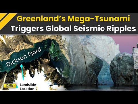
Satellite breakthroughs uncover a colossal landslide in Greenland’s Dickson Fjord, shaking the Earth for nine days and rewriting tsunami science.
- 25+ million cubic yards of rock and ice fell—enough to fill 10,000 Olympic pools.
- 650-foot tsunami wave swept through Dickson Fjord, Greenland.
- 9 days of global seismic pulses every 92 seconds were detected worldwide.
- 70+ scientists from 41 institutions unlocked the mystery.
In September 2023, a remote Arctic cliff quietly collapsed, unleashing one of the most astonishing natural events in modern memory. Over 25 million cubic yards of rock and ice—roughly the size of a small city—plunged into Greenland’s Dickson Fjord, generating a monster tsunami, pounding shockwaves that echoed around the globe, and a seismic mystery only technology could solve.
The world’s seismic networks, usually abuzz with earthquake drama, registered a hauntingly rhythmic beat from Alaska to Australia. Once every 92 seconds, for nine straight days, the Earth’s crust pulsed with an intensity unseen before—a phenomenon almost no one witnessed in real time, but whose forensic evidence fascinated scientists everywhere.
Q: What Caused Greenland’s ‘Heartbeat’ to Echo Worldwide?
The culprit: a dramatic landslide at Dickson Fjord on September 16, 2023. The collapse unleashed a 650-foot-tall tsunami wave that barrelled down the narrow fjord corridor, rebounded, and set off a colossal sloshing effect called a seiche. This back-and-forth motion raised and lowered the water’s surface by up to 30 feet, with such force that it battered instruments around the world for days.
Unlike typical earthquakes, this event sent out smooth, repetitive peaks in the seismic data—an unmistakable fingerprint. The unique pattern grabbed scientists’ attention and instantly became an international mystery.
How Did Scientists Crack the Fjord Tsunami Enigma?
More than 70 researchers from across 41 institutions joined forces, using everything from field surveys to supercomputer simulations. According to the U.S. Geological Survey, on-site teams mapped fresh scars on the towering cliffs, while computer models recreated the event’s physics. Supercomputers confirmed the massive wave and prolonged seiche were triggered by the landslide’s unstoppable energy.
International collaboration and interdisciplinary analysis held the key: seismic traces, satellite imagery, and direct observations all aligned with the singular landslide, ending speculation about the event’s cause.
Why Did This Happen—And What Does Climate Change Have to Do With It?
Experts now point squarely at climate change. Dickson Fjord’s cliffs once leaned safely against thick glacier ice—now rapidly retreating as Arctic temperatures surge. As these icy braces disappear, slopes become unstable and colossal landslides, like the one in Greenland, become more likely.
Similar instability in Greenland’s Karrat Fjord famously caused a deadly tsunami in 2017. The Dickson incident, fortunately, struck in an uninhabited area, but the potential for tragedy looms as high-latitude regions warm and cruise ship travel increases.
How Are Satellites Changing the Game in Disaster Detection?
Traditional radars see only slivers of the landscape. In 2022, however, NASA and partner agencies launched the Surface Water and Ocean Topography (SWOT) satellite—a game changer in Earth observation. SWOT mapped Dickson Fjord’s entire surface in stunning detail, catching the signature of the mega-wave swirling days after the landslide.
Researchers from University of Oxford and leading agencies agree: advanced satellites and real-time sensors are now vital for monitoring remote, rapidly changing environments—and will play a critical role in early-warning systems for future hazards.
What Does the Dickson Fjord Event Teach Us About Future Risks and Preparedness?
Scientists are now combing historical data for similar seismic pulses. Every new discovery sharpens models of how rockslides, fjord shapes, and water depths combine to produce devastating tsunamis. The ultimate goal? Early warnings delivered in real-time to ships and Arctic communities, potentially saving countless lives.
The Dickson Fjord mega-tsunami reminds us that even the quietest corners of Earth can hold secrets capable of global impact. Cutting-edge technology—including satellite constellations and machine learning—are rapidly expanding humanity’s ability to monitor wild environments as our planet warms.
Stay informed, stay safe: Keep up with the latest breakthroughs in Earth science and climate monitoring. Here’s what you can do:
- Sign up for global seismic and weather alerts.
- Watch for early-warning technologies aboard Arctic cruises.
- Read more from official science sources like Nature and Science.
- Download apps like EarthSnap for real-time Earth monitoring.
Checklist for Arctic Disaster Readiness:
- ✔️ Monitor satellite and seismic feeds when traveling in polar regions
- ✔️ Support climate science and adaptation efforts
- ✔️ Stay updated on new technologies for disaster forecasting
- ✔️ Share Earth science news to help others stay prepared